The Charlotte Observer states the following statements about recently departed Hurricane Arthur:
Arthur surprised National Hurricane Center meteorologists in two ways -- by growing stronger than originally expected, and by veering a bit farther west than first thought. Arthur was forecast originally to be an 80 mph hurricane, but its top winds grew to 100 mph Thursday as it moved northward, parallel to Myrtle Beach and Wilmington. It also originally was expected to brush the edge of the Outer Banks.
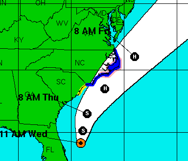
This is the farthest-west forecast made by the National Hurricane Center of Arthur:
The point of landfall was clearly within the white area and was on all of the previous and subsequent NHC forecasts. I do believe some people might have been mislead by the solid line showing the "most likely" path.
That is why I omit the "most likely" path from the forecasts posted on this blog. It infers a level of skill we do not have.
Conclusion: You can be confident the hurricane will be inside the white area but not necessarily the most likely path.
Now, with regard to wind speeds. There is less skill at forecasting forecasting wind speeds as opposed to paths; the latter has become quite good.
However, this blog was talking about 100 mph winds very early in the process. Here is this blog's forecast from 6:47pm Wednesday:
Conclusion: There were at least some meteorologists forecasting 100 mph winds in plenty of time to prepare.
As many of you know, I teach businesses and governments how to prepare for extreme weather. Both peer-reviewed research and my experience both clearly demonstrate that you are better using one or, at most, two trusted sources rather than trying to gather a large number of sources and averaging them.


No comments:
Post a Comment